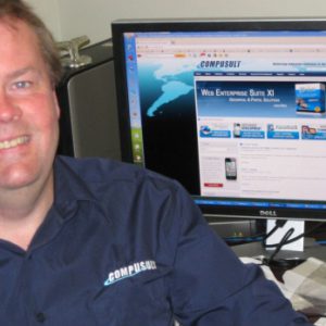
by Andrew Safer:When Hurricane Igor struck Newfoundland in November 2010, emergency response crews sprang into action to mobilize assistance, assess the damage, and forecast Igor’s path. Paul Mitten, Vice President of Compusult, says GO Mobile, the software product the company launched in mid-October, can give emergency response personnel the tools they need to decide on the best course of action in a disaster of that magnitude. It’s an app for mobile devices such as the iPhone, iPad and Android-based smartphones and tablets that brings a multiplicity of geographically-referenced data and services to their fingertips.
In the age of citizen journalism, GO Mobile enables people on the ground to upload video of a disaster, as well as data gathered through personal observation. In the case of an oil spill, that might be the number of oiled birds they observe every 100 meters. “We have the most comprehensive standards-based end-to-end package that’s commercially available,” Mitten says, describing not only GO Mobile but also the infrastructure that supports it. The new app integrates with Compusult’s Web Enterprise Suite, a toolset the company developed to create Web portals for geospatial information, integrating disparate datasets from both public and private sources. The information is displayed visually, enabling the user to make sense of vast amounts of data to improve situational awareness.
SensorBay and SensEarth
In late 2007, the Open Geospatial Consortium, an international voluntary standards organization, presented a high-level overview and architecture of the Sensor Web Enablement (SWE) concept to introduce a standards-based approach to Web-based interoperability of sensors, such as tide gauges and conductivity, temperature and depth sensors. In 2008, Compusult is believed to have been the first company in the world to demonstrate a commercial implementation of the SWE initiative.
Through their SensorBay project, Compusult enhanced its Web Enterprise Suite software to enable the local community to access information provided by a variety of sensors located on fixed and mobile platforms in and around Placentia Bay and the St. John’s/Mount Pearl municipal region. High schools, private sector organizations and government agencies collaborated in the collection of the data, which related to community needs including fishing, industrial development, environmental monitoring/management and safety. The project provided direct access to hydrological, water quality, oceanographic, meteorological, vessel movement, and other sensor information.
“Someone who was interested in ship traffic could monitor the oceanographic and meteorological conditions through AIS ship movements, weather stations and oceanographic instruments”, Mitten explains.
In 2009, Compusult’s follow-on project, SensEarth, provided organizations in Canada, the US, and Europe with a catalogue service and client application that made locally-generated sensor data (such as data from instruments in Monterey Bay) available to all of the participants via the Web.
Portfolios
Compusult’s next objective was to provide a means to manage and make sense of the massive amounts of information related to particular emergencies, so they developed a portfolio management system through the Geospatial Platform for Analysis and Decision-Making (GeoPAD) project. This system enables the user to query, retrieve and mark-up location-based information, and combine it into customized portfolios which can then be expanded and updated as scenarios develop. The GeoPAD initiative also supported the development of GO Mobile.
Mitten points to his computer screen showing images of the 8.8 magnitude earthquake off the Chilean coast in 2010. There are separate portfolios for the seismic data, oceanographic data related to tsunamis, wave heights, and satellite imagery, along with video from observers. “You can have a portfolio for each day of the event containing satellite images, sensor data, photos, videos, documents, messages, links to news sites, and RSS feeds,” Mitten says, explaining that information requirements evolve from day to day over the course of a disaster. Whereas most of the company’s sales of Web Enterprise Suite have been to agencies in the aerospace and defence sectors, Mitten and his colleagues are returning to their roots in the oceans sector. (Barry O’Rourke founded the company in 1985 to provide software development and related services to the offshore oil and gas industry.) Compusult exhibited at the last two Ocean Tech shows in Newport, the last two Oceans shows in Seattle and Kona, Hawaii, and the recent Offshore Technology Conference in Rio de Janeiro.
Oil and Gas Industry Applications
The Brazilian multinational energy corporation Petrobras’ tanker fleet will double over the next five years, reports Compusult’s Marketing Director Robert Thomas. He adds that the supply system for the barges on the river systems will see a similar increase. “They need methods to be able to track vessels from a central location,” he says, “and to be able to see what’s going on in the vessels, like the temperature in the hold and the RPM of the engine. Our tool is perfectly suited for doing that. If we had had our software in our pockets, we could have installed it on one of their systems.” Until recently, Thomas explains, the technology required to do this type of standards-based centralized monitoring didn’t exist. “Our software opens up the interfaces to the sensors so anyone can monitor them,” he adds. “Many can now share what was previously stovepiped information.”
Compusult’s suite of products can also be used to provide situational awareness to the operator of an offshore oil and gas project. An operations “dashboard” can be set up to provide near real-time consolidation and visualization of data from multiple sensors on rigs, support vessels and data buoys as well as information from other sources such as ice and weather services and satellites. This would offer a single point of access to a Common Operating Picture overview of offshore operations 24/7 for enhanced situational awareness and decision support.
Local Support
Investments in Compusult’s activities over the past five years have enabled the company to develop these world-class sensor web solutions. Natural Resources Canada’s GeoConnections program invested $231,000 in SensorBay and SensEarth. The Atlantic Canada Opportunities Agency (ACOA) invested $2.3 million through the Atlantic Innovation Fund (AIF) in Compusult’s Geospatial Open Platform for the Sensor Web (G-OPS) project which enabled the company to develop a new Sensor Management module for their commercial Web Enterprise Suite software. ACOA also invested $2 million in GeoPAD through a second round of the AIF which enabled the development of an enhanced Portfolio Manager tool, as well as the new GO Mobile and GeoPAD apps.
Compusult is just completing its 26th year of operation—“a long time for an IT firm,” observes Mitten. He has been with the company since 1987. Thomas joined the team in 1995.